自定义地图数据源
地图创建时需要指定瓦片地图数据源,three-tile 内置了主流厂商的地图数据源定义,但你也可以自定义新的地图数据源,或自行切瓦片、下载离线瓦片使用自己的地图服务。
three-tile 的数据源分两大类:
- 影像瓦片:即我们通常看到的影像地图瓦片。支持 png、jpg、webp 等格式。
- 地形瓦片:即高程数据瓦片,用于地形渲染。支持 MapBox 的 terrain-rgb、ArcGis 的 LERC 格式。
three-tile 的地图数据的加载、解析和瓦片模型的创建使用插件架构实现,可以灵活扩展。 目前加载器插件有:geojson、mvt、tif、wirefram、logo、normal、debuge 等。
1. 内置数据源
包括:ArcGis、MapBox、google、bing、天地图、中科星图、高德、腾讯等等。这些数据源可以直接使用。数据源定义在 plugin 模块。
- MapBoxSource,
- ArcGisSource,
- ArcGisDemSource,
- BingSource,
- GDSource,
- GeoqSource,
- GoogleSource,
- MapTilerSource,
- StadiaSource,
- TDTSource,
- TXSource,
- ZKXTSource
如使用 MapBox 数据源:
// MapBoxToken 请更换为你自己申请的key
const MAPBOXKEY = "xxxxxxxxxxxxxxxxxxxxxxxxxxxxx";

// mapbox 影像数据源
const mapBoxImgSource = new plugin.MapBoxSource({
  token: MAPBOXKEY,
  dataType: "image",
  style: "mapbox.satellite",
});

// mapbox 高程数据源
const mapBoxDemSource = new plugin.MapBoxSource({
  token: MAPBOXKEY,
  dataType: "terrain-rgb",
  style: "mapbox.terrain-rgb",
  maxLevel: 15,
});

// 创建地图
const map = tt.TileMap.create({
  // 影像数据源
  imgSource: mapBoxImgSource,
  // 地形数据源
  demSource: mapBoxDemSource,
  // 地图投影中心经度
  lon0: 90,
  // 最小缩放级别
  minLevel: 2,
  // 最大缩放级别
  maxLevel: 18,
});TIP
虽然内置数据源可以直接使用,但建议大家最好还是自己定义,因为地图服务商的数据源 url 常常会发生变化。对于一个开发框架,内置可能会发生变化的规则并不太合理,但为了方便初学者使用还是放在框架里了,也是由于此原因,数据源的定义放在 plugin 模块。
2. 自定义数据源定义
three-tile 支持自定义地图瓦片数据源,与 leflet、mapbox、cesium 等用法类似,使用 TileSource 类创建,支持 WMTS、TMS 规范瓦片服务,仅需提供瓦片服务 url 模板即可。如:
  // 定义opentop数据源
  const opentopImgSource = TileSource.create({
    subdomains: "abc",//子域名
    url: "https://{s}.tile.opentopomap.org/{z}/{x}/{y}.png",// 瓦片url模板
  });
}将 opentopImgSource 传入 TileMap 的构造函数即可;也可以在运行时修改 TileMap 的 imgSource或demSoure 属性完成地图切换。
数据源的定义可以采用 3 种方式:
- 工厂函数创建:
- 继承方式定义:
- 实现数据源接口:
2.1 工厂函数创建:
TileSource 类提供了一个静态方法 create 来创建一个数据源,一般情况下可以使用该方法创建数据源实例(也可以使用 new TileSource())。参数如下:
interface SourceOptions {
  /** 数据类型标识,指示用哪个加载器加载,默认为"image" */
  dataType?: string;
  /** 数据所有者 */
  attribution?: string;
  /** 瓦片最大级别 */
  minLevel?: number;
  /** 瓦片最小级别 */
  maxLevel?: number;
  /** 投影方式,默认3857 */
  projectionID?: ProjectionType;
  /** 图层显示时的透明度,0-1 */
  opacity?: number;
  /* 数据经纬度范围 [minLon,minLat,maxLon,maxLat] */
  bounds?: [number, number, number, number];
  /** 瓦片url模板 */
  url?: string;
  /** 瓦片url子域 */
  subdomains?: string[] | string;
}参数比较多,但大部分参数都是可选的,一般只需要传入必须的 url 模板即可。url 模板与大部分 gis 系统一致,抄下来即可。
const mySource = tt.TileSource.create({
  url: "http://127.0.0.1:5500/testSource/img/{z}/{x}/{y}.png",
});

// 设置数据源
map.imgSource = mySource;
// map.reload();//(V0.11.0 后不需要调用)在这里,你可以找到一大批开放的的瓦片数据服务:https://leaflet-extras.github.io/leaflet-providers/preview/
2.2 继承方式定义:
对瓦片坐标非 xyz 形式的瓦片服务,可以继承 TileSource,重写 getUrl 函数,按瓦片规则实现 url 的生成。例如内置的 Bing 的数据源:
/**
 * Bing datasource
 */
export class BingSource extends TileSource {
  public dataType: string = "image";
  public attribution = "Bing[GS(2021)1731号]";
  public style: string = "A";
  public mkt: string = "zh-CN";
  public subdomains = "123";

  public constructor(options?: BingSourceOptions) {
    super(options);
    Object.assign(this, options);
  }

  public getUrl(x: number, y: number, z: number): string {
    // quadKey 函数用于生成 Bing 的 quadkey 算法,此处省略具体实现。
    const key = quadKey(z, x, y);
    return `https://t${this.s}.dynamic.tiles.ditu.live.com/comp/ch/${key}?mkt=${this.mkt}&ur=CN&it=${this.style}&n=z&og=804&cstl=vb`;
  }
}2.3 实现接口方式定义(不推荐):
也可以实现 ISource 接口自定义数据源,不是特殊需求不建议这么做。
TIP
你可以参考 three-tile 内置数据源的实现,代码写的比较凌乱,没把它作为重点,大家可以参考它自行实现:
https://github.com/sxguojf/three-tile/tree/master/src/plugin/mapSource
3. 自定义数据源经纬度范围
如果数据源的经纬度范围不是全球范围,可以自定义范围。
TileSource.bounds:[minLon,minLat,maxLon,maxLat] 用于指定瓦片范围,超出此范围的瓦片将不会被加载,默认为: [-180, -85, 180, 85],即全球范围,可以修改 bounds 属性,设置瓦片的经纬度范围。
4. 瓦片数据类型
three-tile 使用插件架构实现瓦片数据的加载、解析和模型创建,实现对地图数据格式类型的灵活扩展。
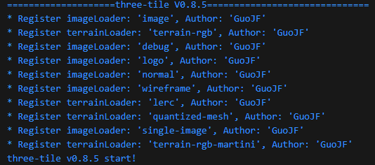
TileSource 的 dataType 属性,用来标识本数据要用哪个加载器插件下载解析,three-tile 内置了多个插件,程序启动时会自动加载,并输出插件信息:

dataType = "image",即用第一个影像加载器 image 插件加载瓦片。
